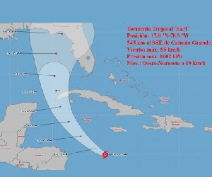
 Tropical storm Ian during this morning has gained in organization, although it remains with little change in its intensity. It continues with maximum sustained winds of 85 kilometers per hour, with higher gusts, and a central pressure of 1002 hectoPascal. Its movement has turned towards the west-northwest, slowing down to 19 kilometers per hour.
At six in the morning, its central region was estimated at 15.0 degrees North latitude and 78.9 degrees West longitude, a position that places it in the waters of the central Caribbean Sea about 545 kilometers south-southeast of Cayman Grande and 780 kilometers to the southeast of Cayo Largo del Sur.
In the next 12 to 24 hours, the tropical storm will begin to tilt its path to the northwest with a similar travel speed, rapidly gaining in organization and intensity, with the possibility of reaching the category of a hurricane this Sunday.
The Forecast Center of the Institute of Meteorology maintains a close watch on the evolution of this tropical cyclone organism, due to the potential danger it represents for western Cuba. Given its position and forecast trajectory, Tropical Storm Ian could cause strong winds, heavy and intense rains and coastal flooding in low-lying areas of the southern coast in this part of the Cuban territory starting on Monday, September 26.
The next tropical cyclone warning for this system will be issued at noon this Sunday.
(With information from the Institute of Meteorology)