 The National Civil Defense Staff reports that, according to the information from the Forecast Center of the Institute of Meteorology in its warning of tropical cyclone No 2 on Tropical Depression No 9 of the current cyclonic season, the forecast models indicate a high probability of organization and intensification of this hydrometeorological event during the approach to the western and central regions of the country, being able to reach the category of hurricane.
Taking into account the evolution of this cyclonic organism, and the risk that it represents for our country, it is oriented to specify the assurances of the disaster risk reduction plans, paying attention to the protection of the population and the resources of the economy, the state and vitality of the emergency generator sets, the collection of solid waste and the cleaning and unblocking of the drainage system in the areas of greatest risk. Increase hydrometeorological surveillance.
The population is advised to stay informed through the media and the official profiles of social networks and to comply in a disciplined manner with the instructions given by the local authorities.
(Taken from the Civil Defense)
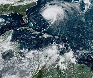
Institute of Meteorology warns about major organization of tropical depression number nine
During the afternoon, Tropical Depression Nine of the current cyclonic season has continued its movement towards the west-northwest, increasing its travel speed, which is now 24 kilometers per hour. The tropical depression maintains maximum sustained winds of 55 kilometers per hour, with higher gusts and a central pressure of 1006 hectoPascal.
At six in the afternoon, the central region of the tropical depression was estimated at 14.8º N and 71.5º W, a position that places it in the waters of the eastern Caribbean Sea about 660 kilometers east-southeast of Kingston, Jamaica.
In the next 12 to 24 hours, Tropical Depression Nine will continue with a similar course and travel speed, inclining its trajectory more to the northwest in the next few days, gaining more organization and intensity, and may become a new tropical storm tonight or tomorrow. the next morning and reach the category of hurricane from Sunday.
The Forecast Center of the Institute of Meteorology maintains a close watch on the evolution of this tropical cyclone organism, due to the potential danger it represents for the western half of Cuba, given its position and forecast trajectory.
The next tropical cyclone warning for this system will be issued at midnight on Friday.
(With information from INSMET)