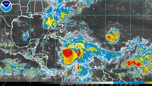
 As powerful Hurricane Matthew advances across the sea south of Cuba’s eastern provinces, weather conditions are expected to deteriorate this afternoon, October 4, with heavy rainfall reaching totals of 200 to 300 mm, and up to 500 mm in mountainous areas, as well as flooding along the region’s south-eastern coast and that of Guantánamo and Holguín on the northern shoreline.
Dr. José Rubiera, from the Institute of Meteorology’s Forecast Center, indicated that the storm should continue its trajectory to the north, with landfall on the island projected to take place tonight at some point along the southern coast of Guantánamo. By the end of the afternoon, winds of over 120 kilometers per hour will be felt in the province.
He emphasized that Matthew continues to be a hurricane of large dimensions, with an extensive area of heavy rainfall. Tropical storm force winds will be felt within a radius of 295 kilometers from the eye of the storm, while hurricane force winds will hit an area with a diameter of close to 110 kilometers.
This means that a large portion of the eastern region of the island will be at risk, Rubiera stressed, while noting that the storm could still move west.
At 8:00pm, Monday evening, the category 4 storm was located 370 kilometers south of Guantánamo, with sustained maximum winds of 220 kilometers per hour.
(Granma)